Thursday, July 28, 2016

Bound for Petersburg


A Beautiful Classic at Pack Creek
A beautiful classic wooden boat had come into the bay to anchor on the last night of our stay at Pack Creek.  Passengers gathered in the fantail of the ship for the evening’s social hour or perhaps for a meeting to prepare for their Pack Creek experience the following day.  We left the anchorage in the morning at 8:30 and headed back south along Seymour Canal motoring with one engine.  We have made a new practice of running on only one engine as we depart and arrive at an anchorage site which helps save on engine hours and reduces our speed.  
"Smart Controller Board" (circuit board) on Got d' Fever
After exiting the bay, we started the second engine and noted that the low voltage alarm was chirping and that the meter (battery monitor) was not showing a charge.  Leonard surmised that the problem could be one of two scenarios:  the alternator(s) were not providing DC charging (one alternator per engine), or the “smart controller board” (circuit board) was defective.  He reasoned that it was unlikely that both alternators would go out at the same time.  Going to the engine room, he looked at the “smart board,” which electronically controls the amount of charging that the engine alternators are putting out, and noted that the three LED lights on the circuit board were not lit; ah ha, it must be a fuse - good thing we carry spares.  He replaced the deteriorated fuse and we were back in business.  This little fuse has now been added to the list of scheduled maintenance items, something to be replaced after every 2,000 hours of motoring.  
Baird Glacier north of Petersburg
As someone once said, “cruising is all about working on your boat in exotic places.”  After spending about 30 minutes, we were on our way again, riding choppy 2-foot seas under overcast skies.  We reached Stephens Passage around noon where we saw several whales.  As we approached Bill Point on Whitney Island, numerous whales were seen in all directions, another great spot for excellent whale watching.  In fact we saw a couple of tour boats in the area along with their smaller skiffs for a more adventuresome, close-up look at the whales.  The nearby small islands, including “Five Fingers” and the changing current no doubt create a favorable feeding ground for the whales and opportunities for boaters to see these magnificent creatures.  
Sea Lions on a Channel Marker near Petersburg
We motored past the tour boats into Cleveland Passage, an anchorage tucked behind Whitney Island off mainland Alaska and set our hook for the night.  Cleveland Passage was once the site of a Fox Farm and pilings from the docks can still be seen along the shore.  The following morning we rounded Cape Fanshaw and entered Frederick Sound heading southeast.  As we neared Petersburg, the sun shone through the clouds and we could see Baird Glacier in the distance.  
Fishing Boat Aground, Petersburg
The seas had flattened to a gentle ripple, but we would soon be entering the narrow passage into Petersburg where the current would be running at a swift pace.  Sea Lions were sunning themselves on the channel markers as Petersburg came into view.  Further down the channel, we could see that a fishing boat had gone aground along the shore; an ominous reminder to keep a vigilant watch and not leave your boat unattended while anchored in the swift moving waters of this channel.
Petersburg
As we approached the marina docks, we radioed our request for a slip assignment where we would spend the next ten nights at this Southeast Alaska home away from home.             

Tuesday, July 26, 2016

Wild Kingdom at Pack Creek


Spirit Quest along Seymour Canal
We departed Short Finger Bay anchorage in rain and low cloud cover but decided that the bears at Pack Creek probably wouldn’t be deterred by the weather.  Salmon (Chums and Pinks) would be making their way upstream to spawn and we were hopeful that bears would be there actively feeding.  As we continued north along Seymour Canal peering through the fog, we made out the familiar outline of a boat heading towards us, it was none other than our friends on Spirit Quest who accompanied us in Haida Gwaii and later joined us again in Ketchikan and Thorne Bay.   We contacted each other by radio and mutually shared where we had been and what we had seen.  It was nice chatting with them again.  
The Dinghy Clothes Line at Pack Creek
After a short two-hour motoring we were at Pack Creek on Admiralty Island and proceeded to set the anchor just off shore.  Pack Creek is a Brown Bear Wildlife Sanctuary with two designated view points for visitors – one located along the shore where Pack Creek empties into Seymour Canal, and the other located at the end of a mile-long trail where an observation tower overlooks the creek.  The bears have learned that humans congregate in these two areas and traverse the trail, thus becoming what is called “habituated” – understanding the area of human movement and that humans are not a threat.  
Tourists waiting for Bear Sightings
Stan Price, an early homesteader at Pack Creek (mid-1950’s) played a large role in habituating the bears.  He and his wife raised several orphaned cubs which later raised cubs of their own.  Price maintained his residence until his death in 1989, only remnants of their garden at the shore viewing area remain today.  In 1990, the Alaska State Legislature designated the Stan Price Wildlife Sanctuary to include the tidal area at Pack Creek, co-managed by the Forest Service and Fish & Game.  After setting the hook, we contacted Pack Creek for permission to come ashore but we were told to standby as a bear was roaming along the beach.  
Brown Bear Sow (29yrs old)
We were contacted a few minutes later and given the all-clear, and also reminded to bring our permit which we had printed off from our online payment and registration.  We took the dinghy ashore and tied-up to the “clothes line” provided for visitors.  After stepping ashore and securing the dinghy to the clothes line, we helped our host pull the line toward sea, allowing the dinghy to float safely above the sea bottom throughout the large tidal change.  
The Old Sow catching a Fish
After a short orientation and receipt of an informative booklet about bears, we were directed to walk along the shoreline out to the designated viewing point.  
The Old Gal walking past the tourists and along Pack Creek
Others who had flown in by seaplane had gathered here earlier and were patiently waiting for a bear to appear.  After some time, we were beginning to wonder if the tourists from Florida and California with their designer clothing and telephoto cameras were going to be our only source of wild and amusing encounters.  Finally an old sow came walking along the beach and headed up Pack Creek near the view point.  Bears can live to be 30 years old and this old gal was already 29.  
Mile Long Trail to the Observation Tower
We watched in silence as she lumbered past, paying us no mind while cameras rapidly clicked away like the chatter of birds.  Afternoon was quickly approaching so we walked back to our dinghy for a lunch break aboard Got d’ Fever and planned to go ashore later to hike the one-mile trail to the observation tower.  
Observation Tower overlooking Pack Creek (a salmon head on the boardwalk)
The tide would be coming in, pushing the fish up stream for the bears to more readily harvest their dinner.  We received permission to hike the trail built by the CCC’s (Civilian Conservation Corps) back in 1935 when the Forest Service first selected Pack Creek as a Brown Bear viewing area.  The trail is well maintained and apparently the bears like it as well since we saw numerous piles of scat, some very fresh.  
Brown Bear walking up Pack Creek towards the Tower
We were told that if we saw a bear on the trail to simply stop, hold still, and let him or her take a course around us off the trail.  We safely reached the tower overlooking the Creek and climbed the steep stairs where we found a sign-in guest book; we were the only people there and had the place to ourselves.  The swiftly moving stream was active with spawning fish but no bears in sight.  
Brown Bear finds his Dinner
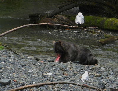
Before long however a bear appeared walking up the Creek looking for his meal.  Splashing about and running through the stream, he snatched up a fish and began his feast.  Soon another bear appeared, and then another, passing directly below the tower.  We were witnessing the real thing, nature at its best – a bear on the hunt for fish, ripping its catch asunder to fill his belly while spawning fish fought to survive long enough to lay and fertilize their eggs.  
Feasting on Salmon
Eagles and Gulls picked up the scraps while smaller birds picked up salmon eggs that had risen to the surface of the stream.  Evening was approaching and i
t was time for us to hike the trail back to shore.  We had our whistles and bear spray at hand just in case.  As we rounded a corner, we met the summer resident artist hiking up the trail, he told us he had just met a bear on the trail that finally moved away proceeding down the hill.  
A Ferocious Appetite
Oh darn, he had scared the bear off but maybe it’s just as well since the guy seemed a little shaken from the encounter.  We kept moving and reached the shore-end of the trail where we noted that a large “trail entrance sign” had become a scratching post for the bears who apparently love the taste and smell of cedar.  We were told that the sign was quickly shredded shortly after it was installed, better the post than the humans!  
Is that a bear on the trail?
After reaching the shoreline, we looked around and realized that we were the only visitors remaining. 
Before the salmon arrive to spawn, bears feast on young plants in the spring such as skunk cabbage roots, sedges (grass-like plants) found along the beach, and then devils club in early summer.  During low tides, the mud flats provide access to clams and mussels easily dug up with their long claws.  The mountain slopes provide an abundance of berries also found in early summer including salmonberries, crowberry, cranberry, huckleberry, and blueberry.  Between July and August, bears often alternate between fish and vegetation increasing their weight 25 percent.  
The Bears' Scratching Post
Once satisfied and fattened up, the bears find their dens for the winter to restart the cycle all over again.  We gained a better understanding of the bears’ world and thoroughly enjoyed our visit to Pack Creek, a wild and beautiful place.

Monday, July 25, 2016

Sea Life in Seymour Canal

 
Sumdum Glacier in Endicott Arm seen from Stephens Passage
 
After waiting several days for rain and 30 knot winds to pass, we departed Juneau on Monday, July 25th making our way southward along Gastineau Channel and Stephens Passage. 
Ice Bergs in Stephens Passage
Ice bergs could be seen at the entrance to Endicott Arm and we could see beautiful Sumdum Glacier in the distance from Stephens Passage – the same area where Got d’ Fever and companion vessel Uno had taken photos in front of the ice bergs a year ago.  
Seymour Canal
Continuing south, we rounded Point Hugh on the east side of Admiralty Island and turned back north, motoring up Seymour Canal.  We found ourselves on the opposite side of Admiralty Island from the Native village of Angoon which we had visited a couple weeks earlier. 
Whales everywhere in Seymour Canal

This beautiful Canal terminates near the northern end of the Island so we were surprised to see so many humpback whales in the vicinity; perhaps this is a favorite feeding stop on their way north, the whales seemed to be everywhere.  
Whale Activity in Seymour Canal
Not to be outdone, the Dall’s Porpoise came to ride along the bow of Got d’ Fever, doing their usual antics of crossing directly in front of our boat with extraordinary speed.   
Dall's Porpoise playing with Got d' Fever
Seymour Canal turned out to be a great place to find sea life at play and we hope our luck holds tomorrow when we visit Pack Creek, a Brown Bear Sanctuary on Admiralty Island.  Until then, we enjoyed our anchorage for the night in Short Finger Bay located on the east side of Seymour Canal.


Dall's Porpoise
Seymour Canal
Anchored in Short Finger Bay, Seymour Canal
Short Finger Bay, Seymour Canal

Thursday, July 21, 2016

Juneau’s Alaska State Museum


State Museum and Library, Juneau
 
A new facility for the Alaska State Museum and State Library & Archives in Juneau opened in May of 2016.  
Museum/Library Foyer, Juneau
The building with its modern architecture has a large foyer with the map of Alaska and the Kamchatka Peninsula of Russia etched in the flooring – viewed in its entirety from the second floor Library.  
Foyer Floor Map of Alaska
As boaters we enjoyed studying the various waterways and major towns, the Aleutian Chain, and the close proximity of Alaska and Russia.  The excellent Museum downstairs includes artifacts from early Native cultures and covers the mining, fishing, and shipping industries of Alaska.  
Tribal May of Alaska
A
nother map of interest in the Museum illustrates the Native tribes of Alaska by area, a nice reference when viewing the clothing, baskets, tools, and other objects of skilled crafts from the various Native cultures.  The Tlingit controlled the river routes into the interior via the Chilkat, Chilkoot, and Stikine Rivers and grew wealthy as trading middlemen.  
Tlingit Clothing influenced by Trade
Trading facilitated the exchange of cultures and dress styles, both Native and non-Native.  
 Baskets of the Aleut
For thousands of years, the Aleut wove baskets from carefully selected and cured beach grass, some of the finest basketry in North America; the Aleut used different techniques to make a variety of useful objects. 

The Haida, Tlingit, and Tsimshian made bentwood boxes and bowls by using heat and steam to bend the wood into desired shapes.  
Bentwood Boxes and Bowls
The hulls of ocean-going canoes were heated in order to spread the sides, increasing the canoe’s capacity.  The Unangax, Alutiiq, and Yup’ik hunters made visors and bowls by bending driftwood planks; visors were obviously used long before our own current dress trends.  The Athabascans discovered that many plants have specific medicinal properties and scientists today consider this traditional knowledge a valuable resource.  
Yup'ik Under-Jacket made from animal gut
The largest Native population in Alaska today is the Yup’ik with a population of more than 23,000 distributed among 56 villages, Bethel being the regional center.  The Yup’ik and the northern Inupiat survive in the harsh climate of the Arctic Ocean with traditional hunting.  
Yup'ik Kayaks
Much of their diet still comes from the traditional wild harvest of whale, fish, and land animals such as caribou.  The northern Yup’ik kayak was long and narrow; these kayaks were used to herd Beluga whales during a falling tide and drive them into shallows or up sloughs for capture.  
Model of The USMS North Star
Also of interest was a model of the USMS (United States Motor Ship) North Star which wintered in Seattle and brought supplies, fuel, and teachers to the isolated Native villages along Alaska’s coast during the summer months from 1932-1940.  These supply runs continued after WWII from 1945-1949.  The North Star was replaced by the North Star II and III which carried out the same annual voyages until 1984.  We found the State Museum in Juneau to be well organized and informative, approaching the excellence of the museum in Anchorage, both Museums are worth a visit.      

Tuesday, July 19, 2016

Gold in Those Hills!


A-J Mine Entrance, Juneau
A tour took us underground today at the A-J Mine site accessed on the southeast end of Juneau.  Visitors can purchase tickets for the underground mine tour at the Tramway ticket office where a bus provides transportation to the mine site.   
Numbered Name Tags used by the Miners
In the late 1800’s George Pilz hired Joseph Juneau and Richard Harris to conduct additional prospecting along the Gastineau Channel after Chief Kowee of the Auk Tlingit showed him ore samples from the area for which the Chief received a reward for his efforts.  Juneau and Harris found a large gold deposit at the head of “Gold Creek,” which became the A-J Mine; the Treadwell Mine was also developed across the Channel on Douglas Island.  
A-J Mine Tunnels, Juneau
It was the discovery of the A-J and Treadwell gold deposits that eventually led to the location of Alaska’s State Capitol at Juneau.  People were drawn to the mining camp which soon became a small town, the first to be founded after the purchase of Alaska.  The mill that processed the gold from the A-J Mine was begun in 1900 by Joseph Gilbert and Col. W.J. Sutherland under the name of AK Perseverance Mining Co. which was later changed to the AK-Gastineau Mining Co. 
Crystal hints at possible Veins of Gold
In the early 1900’s an average of 900 miners were employed and 4,000 tons of ore were being crushed daily.  Electricity was required to run the multiple mines and mills in the area so the Salmon Creek Dam was constructed bringing hydroelectric power to Juneau.  The Capitol building in downtown was built in 1929 and dedicated as the Federal and Territorial Building in 1931, Alaska did not become a State until 1959.  Our tour bus took us south along the Gastineau Channel before winding up a steep gravel road to the mine site.  We were met by our tour guide, a full-blooded Tlingit Native and recently retired miner who led us into the mine's tunnels.  He described various mining techniques and operated equipment left in the tunnels for demonstration purposes.  
Air-Compressor Drill, A-J Mine (note holes and chalk marks)
Early miners used hammers and iron rods to create holes in the rock for blasting with dynamite.  The dynamite had a 1-foot fuse, giving the miners only a minute to run for their lives.  The ore was carried out of the mine by rail in ore cars and crushed into a powder.  The gold was initially separated using a combination of gravity and centrifuge action.  In later years a form of cyanide treatment was used to sort out the remaining gold while smaller mines used mercury for separation.  
Fresh Air System, A-J Mine
In 1934, all of the Alaska-Gastineau Mining Co. properties and assets were purchased by the Alaska-Juneau Mining Co.  It was in the 1930’s that new innovations and safety procedures were added:  dynamite with 6-foot fuses, air-compressor drills, air-ducts to extract dust and fumes, and a survival room stocked with water and food to last a week.  
Ruins of the Gastineau Mill at A-J Mine Site
After our tour of the underground mine, students guided us around the mill site providing additional information and the opportunity to see more mining equipment and the mill ruins.  Today, there are two active mines near Juneau – Greens Creek Mine, an underground zinc, lead, silver, and gold mine located on Admiralty Island, and the Kensington Gold Mine located about 45 miles northwest of Juneau.  
Archival Photo, Gastineau Mill at A-J Mine Site
Our guide who took us through the mine said he had enjoyed being a miner and the hard work is rewarded with good pay – a miner today earns from $85,000 to $150,000 per year in wages, open to both men and women.
Side-Dump Ore Car

Sunday, July 17, 2016

Juneau’s Vertical Views


Approaching Juneau along Gastineau Channel
We left Hoonah at 7:50am for the nine-hour cruise to Juneau which Leonard said would cure my SDS (shopping deficiency syndrome).  While we were at Hoonah the cruise ship had not yet arrived so the shops at the Cannery were closed and Juneau beckoned to fulfill this deficiency.  
Juneau backed by Vertical Mountains
But Juneau has much more going for it than just shopping, including beautiful Mendenhall Glacier, Juneau’s Last Chance Mining site, and the extensive trails through the ruins of the Treadwell Mining site in Douglas located across Gastineau Channel, (see posts dated May 12, 14, and June 9 from our 2015 blog).  
Goldbelt Mount Roberts Tramway, Juneau
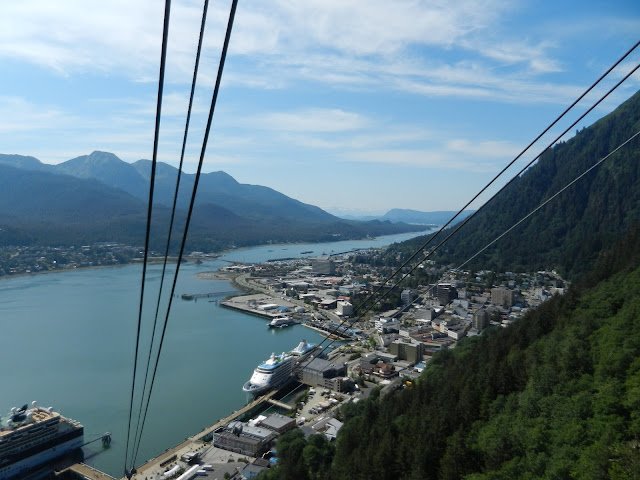
This year we took the opportunity to ride the Tramway, a vertical rise up Mount Roberts, offering spectacular views of Juneau, Douglas, Gastineau Channel, and the Chilkat Mountains.  Built in 1996, the Tramway will be celebrating 20 years of operation this August 10, 2016.  
Riding the Tramway, Juneau below
The Tramway is owned and operated by Goldbelt Incorporated, a Native corporation founded as a result of the Alaska Native Claims Settlement Act (ANCSA).  Currently there are more than 3,600 tribal member shareholders, primarily of Tlingit descent.  Funds from admission tickets support the corporation and help shareholders with job opportunities, scholarships, and the like.  
Gastineau Channel seen from the Tramway
We were fortunate to have beautiful weather revealing incredible vistas both from the tram itself and along the trails above the Tramway.  Even the cruise ships looked like toys from the 1,800 foot vantage point.  
Trail behind the Tramway
For the young and more adventurous hikers, the trail continues another 2,000 vertical feet with several switchbacks up the mountain side.  
Continuation of Trail winding up the Mountain Side
As we were hiking the trails to the various platform viewpoints, we struck up a conversation with a young photographer.  I acknowledged that the area was a great place for some beautiful, artistic photos and I soon found myself a subject of his project along with Leonard.  
Gastineau Channel and Town of Douglas
It turned out that he was shooting photos of visitors enjoying this special place to be used for the 20th Anniversary Tramway Celebration!  
Waiting for the Ride Down
Who knows, perhaps we will be in one of the presentation clips.